The municipal center of Jaro is situated at approximately 11° 11′ North, 124° 47′ East, in the island of Leyte. Elevation at these coordinates is estimated at 104.0 meters or 341.0 feet above mean sea level.

DISTANCES
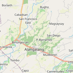
Based on the great-circle distance (the shortest distance between two points over the surface of the Earth), the cities closest to Jaro are Tacloban, Ormoc, Baybay, Catbalogan, Borongan, and Bogo. The nearest municipalities are Alangalang, Tunga, San Miguel, Pastrana, Santa Fe, and Barugo. Its distance from the national capital is 558.47 kilometers (347.02 miles). The following list delineates such distance measurements.great-circle distance
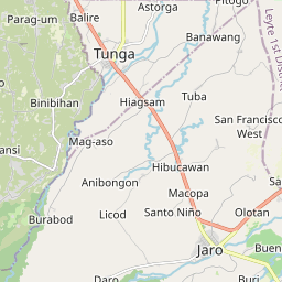
NEAREST TOWNS
- Alangalang, Leyte, 7.22 kilometers (4.48 miles) to the East‑Northeast (N74°E)
- Tunga, Leyte, 7.36 kilometers (4.57 miles) to the North‑Northwest (N26°W)
- San Miguel, Leyte, 12.80 kilometers (7.95 miles) to the North‑Northeast (N25°E)
- Pastrana, Leyte, 12.72 kilometers (7.90 miles) to the East‑Southeast (S63°E)
- Santa Fe, Leyte, 14.55 kilometers (9.04 miles) to the East (S89°E)
- Barugo, Leyte, 15.86 kilometers (9.86 miles) to the North‑Northwest (N18°W)
NEAREST CITIES
- Tacloban, 25.39 kilometers (15.78 miles) to the East‑Northeast (N76°E)
- Ormoc, Leyte, 27.92 kilometers (17.35 miles) to the Southwest (S43°W)
- Baybay, Leyte, 56.60 kilometers (35.17 miles) to the South (S2°E)
- Catbalogan, Samar, 65.82 kilometers (40.90 miles) to the North (N10°E)
- Borongan, Eastern Samar, 85.06 kilometers (52.85 miles) to the East‑Northeast (N56°E)
- Bogo, Cebu, 85.57 kilometers (53.17 miles) to the West (S80°W)
Distance from Manila: 558.47 kilometers (347.02 miles) to the Northwest (N47°W)
NATIONAL RANKINGS
- Population (2015): 43,199, ranked 587 out of 1,634
- Land area (2007): 80.00 square kilometers, ranked 508 out of 1,634
- Population density (2015): 208 inhabitants per square kilometer, ranked 908 out of 1,634
- Annual population growth rate (2010 to 2015): 1.68%, ranked 1,382 out of 1,634
NOTES
- Unless otherwise specified, population count (excluding percentages) and land area figures are derived from the Philippine Statistics Authority.
- Data on annual regular income is from the Bureau of Local Government Finance, Department of Finance
- Postal code information is from the Philippine Postal Corporation.
Source: https://www.philatlas.com/visayas/r08/leyte/jaro.html